

I have been asked on several occasions why the location of the Temple of Jerusalem should be in dispute. Everyone seems fairly certain of its original location why should anyone question this? First of all, I prefer to question everything. Taking anything for granted leaves one at the disadvantage of having to rely upon the opinions of others. I have been educated in the sciences of history, anthropology, economics, mental health, and social work. I have studied the progression of science over time. There have been truths of science taken for a given that were later proved to be disastrously wrong. One can anticipate a great deal of politics in any human endeavor, science, unfortunately, being no exception. Few areas of science are as political and controversial as that of biblical archeology. Competing religious agendas, competing secular academic agendas, and the great facility for human error make this one of the sciences of which all rational people must be most skeptical.
Islamic archeology is often focused on disproving Jewish claims to Israel. Secular archeology is often focused on disproving the biblical narrative. Jewish and Christian archeology, while more often on the right track, can be a little too eager to prove the biblical account and can make errors in their zeal. Overall, skepticism must be the rule. To learn about the archeology underlying the question of the Temple’s location is to step into a major modern political struggle that pollutes the debates and discussions of the subject. As a Jew, I am only interested in the true history of my people: a history seriously obfuscated by a plethora of human agendas. In this article I will examine theories and original sources concerning the Temple’s precise whereabouts.
The late archaeologist Dr. Ernest Martin’s book The Temples That Jerusalem Forgot is one that, albeit imperfectly, examines most of the source materials, eye witness accounts, and historical evidence. In his book, Dr. Martin noted that there is a dissonance between the modern theories concerning the Temple’s location and the original sources. This dissonance is the primary area of exploration for this article.
Challenging Orthodoxy
Modern archeology holds that the Temple of Jerusalem was once located where the Dome of the Rock stands today. This theory is generally accepted by most archaeologists and theologians, although there are a few, as with the aforementioned Dr. Martin, who have dared to dissent from this orthodoxy. While the evidence is incomplete and I cannot endorse Dr. Martin’s theory, the evidence that modern archaeology may have it wrong is quite compelling. Further research and investigation are warranted. Unfortunately, for political reasons this is a touchy subject and there is very little interest in the subject.

Why is the location in dispute in the first place? When the Romans destroyed Jerusalem in 70 CE they completely destroyed it. The city was dug up and buried. The city’s destruction was part of a major rebellion against Rome by the Jews of the region. The Roman General Titus’ response was essentially, to drop the ancient version of the A-bomb on the city. Traveling through the area about 60 years later Emperor Hadrian would report that the entire area was made up of fields being cultivated to feed the Roman garrison (the 10th Legion) in the fortress. He is very clear that the only structure to survive the destruction of Jerusalem was a fortress. He later built a city there due west of that fortress called Aelia Capitolina and a temple to Jupiter on that fortress; this incited the Bar Kochva Revolt. Over the course of the succeeding centuries much has been built on top of the ancient city. There is very little physical evidence today from which to reconstruct the ancient city’s precise layout. No maps or images remain of the city in the time of Herod.
Imagine if New York were blasted with a nuclear weapon, and almost all historical information about the city was destroyed; and a few centuries later it was rebuilt by a foreign power. A couple thousand years after that, historians and archeologists would be commended for correctly identifying the East River, but might never be completely certain of the location of the Empire State or Chrysler buildings.
In the years following the First Crusade, a Spanish Jew named Benjamin of Tudela travelled through Jerusalem. He was the first source to place the Temple at the same location as the Dome of the Rock. Jews began to pray at the location now identified as the “western wall” (Kotel) only about 400 years ago. Modern archeologists are, thus, basing their theories off of modern reports from non-eye witnesses and upon what they see standing today. This is a serious error, as such clues can often be misleading.
I became interested in the subject a few years ago while reading the Jewish Wars by the historian Josephus. As I read, I compared what Josephus wrote with maps and drawings of ancient Jerusalem as presently understood by modern archeology. It wasn’t long before they stopped adding up. Several descriptions by Josephus directly contradict what modern archeology holds to be true. Upon further investigation, I found commentaries by modern archaeologists that suggest Josephus is wrong. I looked for other evidence from the time. Tacitus, in quoting travelers who had been to the region, the Letter of Aristeas, and the account of Hecateus (a Greek historian) state that Jerusalem was a crescent moon (or semi-circular) shape, that the great Temple was near the center of the city, and that there was a spring directly beneath the Temple. The mount upon which the Dome of the Rock stands today was outside of the original city of Jerusalem, and is some distance from the nearest spring: the Spring of Gihon in the City of David.
It is very possible for a single account to incorrect. Several accounts that concur with one another are not as likely to be incorrect. What surprised me is that modern archeologist are aware that their theories vary from these original accounts. They have many excuses and explanations for these or simply dismiss them as incorrect. I have also discovered that modern archeological theory, which is endorsed by many theologians of all major world religions, completely ignore the biblical narrative that surrounds the Temple. Second Shmuel (Samuel) chapter 24 and First Divrei Hayamim (Chronicles) chapter 21 both state clearly that the place that was chosen for the Temple was the threshing floor of Aranah (or Arnan) the king of the Yebusi (Jebusites). We do know something about threshing floors. These were flat often stone floors whereon the wheat was threshed to separate the grain from the chaff, which includes the husk around the grain. It is also true that these were never built on mountain peaks. It makes sense that a King’s threshing floor might be on the leeward side of his city, where the wind would blow the dangerously flammable chaff out over the adjoining Kidron valley. The King would have more wheat to thresh and it would also be part of the city’s ritual for many to participate in the threshing. That location would be more consistent with the eyewitness accounts cited earlier.
The scriptures also frequently condemn offerings made in “high places” like mountain peaks as opposed to those made at the Jewish Temple. There are frequent passages that imply or clearly associate the Temple’s location over or near a spring. Several passages place the Temple near the centre of ancient Jerusalem, not beyond its walls to the north.
I searched for alternatives to the accepted opinion among archeologists, there admittedly there are very few. This is only natural given the political sensitivity of the topic. In time I came upon the extraordinary book by Dr. Martin: The Temples That Jerusalem Forgot. Martin outlines in his work the case for a different location for the Temple. When I first picked up the book I was skeptical, but as the evidence mounted I realized with a growing intensity that he was more or less correct in his assertions. His theory is based upon both the biblical account and the ancient eye-witness accounts, including many with which I had already familiarized myself. Far from having to declare the biblical narrative, and the accounts Hecateus, Josephus, and that cited by Tacitus to be fraudulent or erroneous; Martin’s theory uses these accounts in an effort to establish the actual location. His conclusion, essentially, fits all of these accounts. Is it possible that every source or eye witness from over one thousand years ago is wrong? That these accounts disagree with what modern archeology accepts, suggests not that these ancient sources were wrong, but presents the more likely scenario that modern archeology is in error.
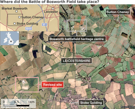
How often have archeologists found that a battlefield was not quite where they had previously thought? The Battle of Bosworth took place in 1485. In the battle Henry Tudor (later Henry VII) defeated and overthrew Richard III, ending decades of warfare called the Wars of the Roses. A recent study found that the battle more likely occurred to the south west of the currently identified site. Many cannon balls and pennants known to have been distributed by Richard were found at the newly rediscovered site. If archeologists and historians could be wrong about the location of a celebrated battle that took place just over five centuries ago, how can archeologists be so absolutely certain about the location of a building destroyed two millennia ago from which so little evidence remains? The truth is, they are not certain. No one wants to shrug their shoulders and say ‘I don’t know;’ especially academics. So they make educated guesses, guesses which can prove incorrect.
Dr. Martin’s work is thorough, scientific, and professional. As a Christian scholar, he was familiar with accounts I might not have considered relevant, including those of early Christian sources Barnabas and Jerome. His method as an archeologist is sound and objective. While anthropologists do what they can to claim their biases, archeologists rarely do so. While, I will discuss some of the evidence here, only by reading his book can one fully contemplate the evidence presented. It is easy to become overwhelmed in learning about the ancient world. Perhaps it is enough to learn about these ancient accounts, about the Temple, and to come away with a more open mind on the subject. In any case, we must not allow any theory to pass without rigorous examination and proof.
History of Jerusalem
Before discussing the Biblical and eye witness accounts of Jerusalem it would be helpful to explore the history of the city.
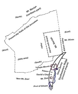
The Jebusites, who occupied the city before David conquered it, chose the city for its obvious strategic position. It is at high enough elevation that it is neither as hot nor as humid as the coastal plains. It is located on the center of north/south and east/west trade routes that run through the central highlands of Kena’an (Canaan), and it is a natural fortress. The Spring of Gihon, the only spring within a five mile radius, provided an abundant supply of fresh water for the city (until 1077 CE). The ridge rises very steeply on three sides and was protected by a ravine to the north. Actually, the whole ridge is part of Mt. Moriah which has four peaks, two in the City of David and two more, on one of which the Dome of the Rock now stands. Mt. Tsion (Zion) and the Ophel (hump) were the two high points on the crescent shaped ridge whereupon the city was constructed.
The walls of the city provided ample defense against foreign armies that occasionally marauded through Canaan. The citizens of the surrounding regions could flee to Jerusalem for protection. As long as the city stockpiled food it was virtually impenetrable. David himself only conquered the city by entering through a sewer.
<div
During this period Jerusalem was the centre of the Jewish world. David and then Shlomo (Solomon) would build up the city and later the Temple therein. It would grow and prosper. It would be besieged by the Assyrians circa 700 BCE and king Hizkiyahu (Hezekiah) would ultimately prevail. The siege by the Chaldeans (Babylonians) would prove to be more destructive in 597 BCE. Many Jews were exiled from the region and the city fell into disrepair. Ezra and Nehemiah would return to the city decades later, rebuild its walls and Temple during the 5th Century BCE. The eyewitness accounts of Hecateus and the Letter of Aristeas date from the late Persian Era. Alexander the Great would conquer the region in 332 BCE and was as generous to the Jews as he was to most of the peoples who had previously been under the Persians. After Alexander’s death, his dominions would be divided amongst four kingdoms. The Ptolemies would rule from Egypt and the Seleucids from Syria. The Seleucid King Antiochus Epiphanies would demand that all his subjects worship him as a deity. The Jews refused and this led to the Maccabee Revolt circa 164 BCE, that saw Jews regain independence for the first time in four and a half centuries.
The Seleucids, ruled by Antiochus IV Epiphanes, were able to prevent the Maccabees from securing Jerusalem for several years because they held the fortress on Mt. Zion. Simon Maccabeus finally drove them from it in 167 BCE after Antiochus lost a campaign against Persia, and soon died after. Simon sought to prevent any future occupier from holding the fortress of Zion. He had the fortress of Zion demolished and moved part of the mountain itself to the north to fill in the ravine that once separated the northern wall of the city from the ridge to the north. He also extended the city to the west and north. Dr. Martin offered more detail on these projects in his book. Simon rebuilt the altar because it had been desecrated with pigs blood. The Temple was reconsecrated and sacrifices resumed. The Book of Daniel, which is primarily filled with visions of the rise of Alexander and the aftermath of his conquest of the region, tells us that the sacrifices and offerings at the Temple would be suspended during a conflagration (the Maccabee Revolt). Daniel stated that the occupation would last for 1290 days – 3 1/2 years (Daniel 12:11). The offerings would be resumed after 1355 days (Daniel 12:12). The time it took to rebuild the altar and reconsecrate the Temple after the occupation had ended was some 65 days.
The Macabees would also build a new fortress on Mt. Moriah called the Baris. The Letter or Aristeas states that there were large cisterns that fed water down hill to the city and Temple below. These cisterns would have had to have been on the mountain under what is now called the Temple Mount, as it is the only terrain in the area that is higher than the city of Jerusalem. The fortress overlooking the Temple and the city would offer greater protection from invasion.
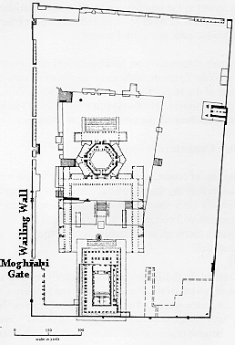
In the image below the internal schematic of the Fortress (mistakenly called the Temple Mount). The smaller square form inside the Haram is the Hasmonean Fortress, called the Baris. Note that the foundation that is the suggested location of the Fortress of Antonia is placed to the north of the Temple Mount, although no foundation or other evidence for the existence of such a structure has ever been discovered. The reason being that the structure now called the Temple Mount was itself the grand Fortress of Antonia. More on this later in another part of this article.
30 BCE – 4 CE
When King Herod finally solidified his hold on the Judean throne around 30 CE, he began a series of projects to improve Jerusalem. He expanded the Temple, and the Fortress on Mt. Moriah, which he renamed Antonia, and he added the New City (Bezetha) to the north of the Hasmonean City.
Eye-Witness Accounts
Hecateus was a Greek historian who travelled to Jerusalem in the late Persian Era, before 332 BCE. His account, excerpts from which have been found in later scholarly works, offers some details about the Temple.

 Biblical Jerusalem is shown here as compared with today’s Old City
The size of the city is of moderate dimensions. It is about forty furlongs in circumference, as far as one could conjecture. It has its towers arranged in the shape of a theatre, [that is a semi-circle or crescent] with thoroughfares leading between them. Now the cross roads of the lower towers are visible but those of the upper towers are more frequented. For the ground ascends, since the city is built upon a mountain. There are steps too which lead up to the cross roads, and some people are always going up, and others down and they keep as far apart from each other as possible on the road because of those who are bound by the rules of purity, lest they should touch anything which is unlawful. It was not without reason that the original founders of the city built it in due proportions, for they possessed clear insight with regard to what was required.
When we arrived in the land of the Jews we saw the city situated in the middle of the whole of Judea on the top of a mountain of considerable altitude. On the summit [highest point in the city] the temple had been built in all its splendour. It was surrounded by three walls more than seventy cubits high and in length and breadth corresponding to the structure of the edifice. All the buildings were characterized by a magnificence and costliness quite unprecedented. It was obvious that no expense had been spared on the door and the fastenings, which connected it with the door-posts, and the stability of the lintel. The style of the curtain too was thoroughly in proportion to that of the entrance. Its fabric owing to the draught of wind was in perpetual motion, and as this motion was communicated from the bottom and the curtain bulged out to its highest extent, it afforded a pleasant spectacle from which a man could scarcely tear himself away.
The construction of the altar was in keeping with the place itself and with the burnt offerings which were consumed by fire upon it, and the approach to it was on a similar scale. There was a gradual slope up to it, conveniently arranged for the purpose of decency, and the ministering priests were robed in linen garments, down to their ankles. The Temple faces the east and its back is toward the west. The whole of the floor is paved with stones and slopes down to the appointed places, that water may be conveyed to wash away the blood from the sacrifices, for many thousand beasts are sacrificed there on the feast days. And there is an inexhaustible supply of water, because an abundant natural spring gushes up from within the temple area.There are moreover wonderful and indescribable cisterns underground, as they pointed out to me, at a distance of five furlongs all round the site of the temple, and each of them has countless pipes so that the different streams converge together. And all these were fastened with lead at the bottom and at the sidewalls, and over them a great quantity of plaster had been spread, and every part of the work had been most carefully carried out. There are many openings for water at the base of the altar which are invisible to all except to those who are engaged in the ministration, so that all the blood of the sacrifices which is collected in great quantities is washed away in the twinkling of an eye. Such is my opinion with regard to the character of the reservoirs and I will now show you how it was confirmed. They led me more than four furlongs outside the city and bade me peer down towards a certain spot and listen to the noise that was made by the meeting of the waters, so that the great size of the reservoirs became manifest to me, as has already been pointed out.

Since the time of the Hasmonean King Shimon (Simon) the Maccabee, Jerusalem has grown to encompass the ridge to the west across the Tyropean Valley (called Zion) and to the north along the Moriah ridge and to its west. The Western (upper) City and City of David (lower city) I will refer to collectively as the Hasmonean City. The Hasmonean Dynasty began with the Maccabees and ended shortly before Herod the Great took power. The Hasmonean City extended north along Mt. Moriah. Herod would expand the city northward to create the district of Bezetha, which would contain a large market place and was home to Jerusalem’s more hellenized or pro-Roman Jews. See the map above.
Extra Biblical Jewish sources also describe the presence of a spring in the Temple include Josephus (Antiquities III 8,6) several passages of the Mishna and Rabbinical commentaries attached to the Talmud, the account of Hecateus (quote provided above), and the Temple Scroll among the Dead Sea Scrolls. The account of Hecateus of Abdera refers to the central location of the Temple within Jerusalem as presented in the Biblical narrative. Aristeas also includes the presence of cisterns from which water flows (down) into the Temple complex. These cisterns may well have been on the south side of the hill upon which the Dome of the Rock now stands. Cisterns, including several from the time of Aristeas, have been discovered in that area and have been recently excavated by archaeologists. It would not have been difficult for water to flow downhill from these cisterns across the ravine that once separated Jerusalem from the hill to the north, and into the Temple complex and the city; providing additional water from rain and snow runoff when the Spring of Gihon was dry.
In addition to the square measurements (about 500 ft square) offered in the Prophet Yekhezkel’s instructions, Josephus describes the Temple mount as a square about 600ft on each side depending upon your interpretation of a cubit (about 14″ to 16″). Even the Mishna, an early book of the Talmud, says the Temple was 500 ama (about 700 ft) square (“Mishna Middot,” Chapter B, paragraph A.) If the Temple Mount was a square, in the time of Josephus and to the Mishnaic Rabbis, who lived at the time of the Temple’s destruction, then why is the Temple Mount as we understand it today a rectangle? Unless it is not the Temple Mount.
Scriptural Evidence
Scriptural evidence paints a very different picture of ancient Jerusalem from the one archaeologists have concocted. The scriptures do not directly address the location of the Temple itself in precise terms (it was 500 cubits south of this or 200 cubits north of that, for example). The authors of most biblical books could readily see the building, its location was obvious to them and thus did not need to be spelled out in detail. They had no reason to think it might one day be demolished and not present for all to see. It is common today to refer to the White House by name, for example, but only rarely as 1600 Pennsylvania Ave. Now imagine if you were uncertain as to the precise location of Washington DC and were trying to pinpoint that location of the White House based upon fragmented references from books and political works that had survived the calamities of history.
The Temple’s precise location is thus vague. There are several important clues to its location in any number of passages that describe Jerusalem. When King Shlomo (Solomon) began expanding the city he filled in the crevasse between the twin peaks of Zion and Ophel. There he built his palace protected on the south by the fortress acropolis of Zion with the palace to the north on the low ground that had been filled; the Temple was immediately north of this. Shlomo expanded the city farther to the north to give it the crescent moon shape that later commentators would see. This construction is described in detail in First Melekhim (Kings) chapters 5-8 wherein the construction of the Temple is the primary matter. Interestingly, the few measurements given for the Temple of Solomon align precisely with the description of the Second Temple given by the priest and prophet Yekhezkel (Ezekiel) in chapters 40-47. The Temple that was rebuilt by Nehemiah and Ezra was to look much the same as that of Shlomo.
There are several references to the presence of a spring within the Temple complex and to the availability of running water. A large laver is included in the Temple complex for the purification and cleansing of the priests (First Kings 7:38). The only spring within 8 kilometres (5 miles) of Jerusalem is the Gihon spring located beneath the Ophel in what is now the village of Silwan. Gihon was the name of one of the rivers in Gan Eden (the Garden of Bliss) referenced in the book of B’reishit (Genesis). The religious significance of the spring is thus worthy of note.
It would have been quite impossible to bring running water to the site now called the Temple Mount in ancient times, as has been previously noted. Only modern pumps could bring water to such a height. Several passages refer to the presence of a spring and connect Hashem’s presence, throne, and blessing with the presence of running water. These include but are not limited to: Yiremyahu (Jeremiah) 17:12-13, Yeshaiyahu (Isaiah) 7:3, 8:6, 12:3, 12:23, Yekhezkel (Ezekiel) 47:1-12, and Tehilim (Psalms) 133:3. There are also references to the Temple’s central position within the city of Jerusalem itself: Yekhezkel (Ezekiel) 11:23, 48:21, Zechariyah (Zachariah) 2:4-5, 8:3, 8:8, and Tehilim (Psalms) 116:18-19. Jerusalem is the centre of the Israelite/Jewish world, and to these authors, the Temple was the centre of Jerusalem. This cannot simply be a metaphor, the Temple must have commanded a physically central location within the Jerusalem of their time. Here the biblical narrative is confirmed by the account of Hecateus.

The Account of the Historian Josephus
Josephus was a priest and a Pharisee who served as a commander during the Jewish Revolt against Rome (66-73 CE). He was captured by the Romans and befriended the General and future Emperor Vespasian. He later wrote lengthy histories of the Jewish People and the Jewish Revolt in the style of a Roman historian. He purports to be an eye-witness to the events he describes. There has been some criticism of his work and there are some doubts about the accuracy of his accounts. In many cases, however, I have found these doubts to be unconvincing. Josephus uses a Roman style of authorship complete with Roman hyperbole, story telling, and the odd anecdote inserted here or there. Nevertheless, the information he provides is plausible and should be considered credible.
The greatest discrepancy between the modern archaeological theories centres around the fortress built by Herod the Great. Josephus reports that it was truly massive. A fortress magnificent in every way and practically impregnable. This fortress could hold as many as three Roman legions. Herod named this fortress after his friend Mark Antony, who had recently died along with Herod’s arch enemy Cleopatra after they lost the Battle of Actium against Octavian, later Emperor Augustus. A Roman legion is about 5000 men at arms with about an equal number of auxiliaries (cooks, sword bearers, slaves, labourers etc..). Could this fortress be capable of housing about 30,000 men? Archaeologists suggest that the fortress was on the corner of the Temple Mount and could hold at most two or three cohorts and their auxiliaries. A cohort is about 500 men, so perhaps 1,000 to 1,500 men. There are several problems with this theory.
During the Jewish Revolt, when Jerusalem was under the control of Jewish authorities, Josephus tells us that these authorities stationed 6,000 soldiers to maintain security during the Passover festival. Josephus claims that as many as 300,000 people came to Jerusalem on pilgrimage, many of them from Babylon then in the Parthian Empire outside of the Roman Empire. The Romans would have needed many more soldiers to maintain order then Jewish authorities, perhaps 10,000 or more during the holidays. In the image below the Fortress of Antonius is depicted as a four towered fort on the north-west corner of what is called the Temple Mount today. Although evidence for the existence of the foundations of many of Jerusalem’s large buildings has been found, no evidence has ever been found for a foundation for the Fortress of Antonia. The existence of this building is entirely a work of scientific conjecture; in other words, it is a fiction.

How Jerusalem looked 2000 years ago according to many
modern archaeologists and theologians
So where was this great, grand fortress of Antonia? The account of Emperor Hadrian states that the city had been entirely buried and that only a fortress remained. An objective assertion then, would be that if there is a structure that survived from that time until this day, it must have been this grand fortress reported by Josephus and which Emperor Hadrian reported to be the only remaining structure from Herodian Jerusalem.
When Titus besieged Jerusalem from 69-70 CE, his efforts to take the city by means of siege engines failed repeatedly. He then turned to the unorthodox: he had his men assault the northern face of the Fortress of Antonia. The fortress was thought impregnable and the city’s defenses were built with that assumption in mind. A breech of the fortress wall would open the city to conquest. The Roman legions successfully battered their way through the wall and into the fortress. The Romans were able to capture the fortress and the new city (Bezetha) in one day. A reasonable assertion given the capabilities and tactics of the Roman Army, except that according to most archaeologists the fortress was located within the city walls. How did the Romans gain access to the northern wall without first breaching one of the city walls? If the fortress was on the north-west corner of the “Temple Mount” then it could not have been accessed by the Roman soldiers without first conquering the northern quarter of the city.
Josephus then states that the Romans required three additional days to seize the Temple. How is this possible? In the image above, the Fortress of Antonius offers an unobstructed view of the Temple Mount. Archers firing from that location could kill tens of thousands of well armed and armoured soldiers (and the Jewish rebels were not) without breaking a sweat and with almost no reprisal from the enemy below. Given Roman military tactics, Roman soldiers would have spilled out onto the platform below and literally crushed and trampled any opposition until they had control of it. The Roman tortoise formation was the ancient world’s version of a tank it could press and trample as a tactic as well as cut and pierce. The Temple must have been on a fortified structure entirely separate from the Fortress of Antonia. Again, there are several references to the severing of the colonnade walkways betwixt the Fortress and the Temple, these must have been separate structures.
Josephus describes the destruction of the Temple by Titus and the Romans. Many people believe that the Romans burned it down deliberately, but this is almost certainly a falsehood. The Romans wanted easy access to all of the gold and silver that was used in the Temple’s construction. If the building caught fire these metals would melt and seep deep down between the cracks of the foundation stones. The Temple did catch fire, it is not clear how this blaze began but it was likely an accident. Titus, seeking precious metals to finance his campaign and secure the throne to which his father had acceded just the year before, ordered the Temple dug up to its foundation stones to recover the gold and silver. If the Temple had been located on what is called the Temple Mount today, they would have had to demolish that structure too in order to access these metals. Christians sources claim that Yeshua (Jesus) made a prophecy that every stone of the Temple would be carried off. This was a central proof for early Christians that Yeshua was at least a prophet, because he had made a prophecy that had come to pass. If this had not been the case, if the foundations of the Temple had remained, would this purported prophecy have become a central idea of early Christian belief?
When the city was captured most of the survivors were made slaves by the Romans. Titus ordered them to dig up the entire city to its foundation stones and then burry it. In the end Titus left only a fortress remaining as a headquarters for the 10th Legion and the former Temple became a trash heap. There is no evidence that what is called the Temple Mount today was ever used as a trash heap. Emperor Hadrian is quite clear in his account when he visited Jerusalem in 132 CE, only a fortress had survived the calamity.

The Temple and adjoining Fortress of Antonia according to the late
archaeologist Dr. Ernest Martin
Dr. Martin’s theory, depicted above, may not be entirely accurate but it fits the evidence better than the current widely accepted theory. There is no reason to believe that the Temple had that particular orientation or that there was a large, tall wall in the SE corner. It is also probable that the Temple Mount was not as tall as depicted here. That said, many of the pieces fit.
Josephus reported that the view of the Temple was obscured from the north by a mountain peak. Where the Dome of the Rock stands today is a peak that would not be obscured by any other peak. If the Temple were south of that peak, however, then the peak upon which the Dome of the Rock stands today would certainly have obscured the Temple. The bridges connecting the Temple to the Fortress of Antonia (now mistaken for the Temple Mount) could have been severed. The Fortress of Antonia was the largest building on Earth at the time it was constructed. Could this building hold three Roman legions? There was probably room to spare. The Romans would also have needed three additional days to conquer the Temple as it was a separate structure the bridges to the Fortress of Antonia having been demolished or broken in some way. Dr. Martin’s proposed location of the Temple would also better fit the accounts given by Biblical authors, Hecateus and Aristeas, and others. Recall the central position within the City of David reported in the Biblical narrative? Dr. Martin’s book has a great deal more detail. Through his work one can find additional evidence for a location of the Temple in the City of David.
There is more than enough real evidence here to challenge the assumptions of modern archeologists. If nothing else, further investigation and research are necessary and the “givens” of modern archeology need to be reexamined. It is unfortunate that so many cling to theories that contradict much of the available evidence.
Why is the Location in Dispute?
When he arrived in Jerusalem in 132 CE, Emperor Hadrian stated that he could not tell that a city had ever existed there. Only sixty years had passed since Titus had ordered the city razed. All that remained of the old city, according to Hadrian, was the fortress (that now served as the 10th Legion headquarters). Hadrian built a new city there, Aelia Capitolina, and a Temple to Jupiter on the Fortress. The architect commissioned to build this Temple to Jupiter also built a temple in Baalbek in modern day Lebanon. Dr. Martin noted that if you overlay the fortress with a bird’s eye view of the architect’s Baalbek Temple (the second image) you can see a striking resemblance to the shapes of the Mosques located on the Haram today. Is it possible that those mosques were built on the foundations of this temple to Jupiter? Quite possibly.
The plans for the construction of Aelia Capitolina and the temple of Jupiter in what had been Jerusalem sparked the Bar Kokhba revolt, the final Jewish Revolt against Rome.

In comparison it is easy to see how the temple at Baalbek is similar to the later temple to Jupiter built by Emperor Hadrian atop the Fortress of Antonia
This is but one example of the many times that Jerusalem has been rebuilt by a new power in the region. This makes discoveries concerning the ancient city all the more difficult because they are buried under dirt and debris beneath houses and businesses that are currently occupied.
History of Jerusalem 135 CE to Present
In 289 CE the 10th Legion was reassigned and the 13th took up station in the region. Their station was transferred to modern day Eilat to provide security for Roman trade interests in the Red Sea. Jerusalem remained the regional capital, but as a small city in a backwater province. In 363 CE the Emperor Julian (the Apostate) reversed the Christian direction of the Roman Empire in favor pre-Christian pagan beliefs; he was also more favourable to the Jews. He allowed Jews to return to Jerusalem to rebuild the Temple. His death and the restoration of Christianity in Rome two years later, ended this work. All that remained of this would-be temple was a wall on the western side that would have been the outer wall of the holy of holies, the much celebrated “Western Wall.” Documents from the Cairo Geniza confirm that both Rabbinic Jews and Karaite Jews congregated there to pray, from the eastern side of the wall praying toward the West. The site now mis-identified as the Western Wall (Kotel) has Jews praying from the western side toward the East, this cannot be the wall identified in the documents from the Cairo Geniza.

Church of the Sepulchre in Jerusalem
Christian pilgrims also poured into Jerusalem. Emperor Constantine and the Byzantine Empire sought to build a number of magnificent churches in Jerusalem. A rumor had been passed around that Jesus had stood on the stone peak that poked out of the so called Temple Mount (Mt. Moriah) when he was being tried by Pilot. How could he have stood there if the Temple had been standing there? Why would people believe this if it had been impossible? This rumor suggests that in that time no one considered what is called the Temple Mount today to be the location of the former Temple. The Church of the Divine Wisdom was built atop the mountain peak outcropping.
In the late 6th and early 7th Century Zoroastrianism saw a period of resurgence in Persia (modern day Iran and Iraq). Zoroastrians do not believe in temples and places of worship in general. In 614 the Sassanid (Persian) King Kosrau II raided Jerusalem and burned many of the Churches, including the one on the so called Temple Mount. The colonnades of that Church still stand in several places all around the Dome of the Rock. The Persians have long been favorable toward Jews, and essentially placed Jerusalem under Jewish administration. Five years later the Byzantines recovered the city and restored it to Christian leadership.
In 637 when Caliph Omar brought Islam to Judaea the city was still in a state of relative ruin. The interactions between Omar and Sophronius, the caretaker of the Church of the Sepulcher, were recorded for posterity. Upon his arrival Omar is said to have sought out a Jew to show him where David and Solomon had prayed. He then took a stone from that place and used it as a cornerstone to build a Mosque that faced it. This Mosque, the Mosque of Omar, is the only Mosque that does not face Mecca. The stone was almost certainly from the remains of the Western Wall built around 363 when Emperor Julian allowed the Jews to attempt to reconstruct the Temple. The rectangular building in the center of the south end of the so called Temple Mount is called the Mosque of Omar and it still sits on there today (see image below) facing south, toward the city of David. It sits on the foundations of the Temple of Jupiter that Hadrian had built five centuries before. Later, the Dome of the Rock would be constructed to the north over the hexagonal courtyard of the Temple of Jupiter that had once stood there.
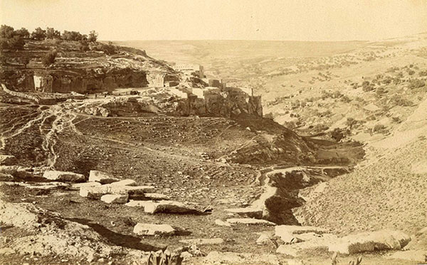
Village of Silwan (Ancient City of David) circa 1870
Omar had promised Sophronius that he would not allow Jews to live in Jerusalem. When Jews petitioned Omar to allow a small community to reside “near the Temple” he accepted and allowed them to move in. How could he keep his promise to the patriarch? As it happens, the Jews wanted to live near the spring of Gihon in the City of David, to the south of (and outside) the city walls at the time. Literally speaking Omar kept promise to Sophronius since the Jews lived outside the city walls of then Jerusalem. Documents from the Cairo Geniza (some of them Karaite) record the existence of this community as well as its location. If the Jews wanted to live near the site of the former Temple, why did they move to the City of David (modern day Silwan) on the ridge to the south of the so called Temple Mount? Perhaps it was because that is precisely where they understood the Temple to have been located.
The Fortress of Antonia (Temple Mount) Today

Modern Rabbinical Judaism is the successor of the Pharisee movement. They hold that there was an oral Torah that was passed down through the generations until it was later written down in what is called the Talmud. In the Middle Ages, Jewish congregations that rejected these Rabbinical commentaries were called Kara’i or “those who read” [the scriptures]. Karaites were later granted the right to separate political leadership by Islamic civil authorities. Free from the power of Rabbinical authorities, Karaites immediately flocked to Jerusalem in the 8th and 9th Centuries CE. The Karaites built a small community on the southern end of the Mount of Olives so they could reside to the east across from the Rabbinical community. These communities were no where near the so called Temple Mount.
In 1077 an earthquake caused the Gihon Spring to become bitter. This earthquake took place on the 1007th anniversary of the Temple’s destruction. It also coincided with the recent conquest by the Seljuk Turks, a people as alien to the Middle East of that time as Vulcans would be to us today. These two events sent most of the Jews packing in anticipation of some great calamity. Some remained, including many Karaite Jews. Many assumed that the end of days were approaching. Those that remained would soon have to contend with a new invader.
The Crusaders arrived in 1099 CE. In their zeal, Crusader armies killed or exiled all Jews after they conquered Jerusalem. They were allowed to return after fifty years. In 1187 Saladin liberated Jerusalem from the Crusaders. Sometime after this, the Karaite Jews returned to the city and built a synagogue in what is now the Jewish Quarter. It is still there today, and is Jerusalem’s oldest synagogue. The synagogue itself was built to face the Ophel and the City of David, not the fortress now misidentified as the Temple Mount; further evidence that the Jews of that time attached no significance to the latter site.

Map approximating the routes traveled by Benjamin of Tudela
Benjamin of Tudela arrived around that time in the Twelfth Century and somehow misidentified the location of the Temple. He was probably taken in by Islamic propaganda, aimed at the eventual recovery of Jerusalem. They had spread the notion that the peak of that mountain had been the place where Ya’akov had wrestled the angel, where the Temple had stood, and where Muhammad had risen to heaven. Benjamin of Tudela had no way on knowing otherwise, and so brought further confusion to the matter. All of the historical sources prior to Benjamin of Tudela challenge our modern conception of how Jerusalem was laid out.
In the years that followed Jerusalem would come under the control of the Ottoman Turks. Modern history has been one of conflict as Jews have sought to reclaim the holy land. The question surrounding the Temple’s location has now become a political one and this has made the matter all the more difficult to explore. Perhaps the time will come in the near future when the tensions will relax and minds will be open to a more rational exploration of the evidence. Until then, I can only pass on what I have found and what Dr. Martin’s expressions discover

I thoroughly enjoyed your article- it was well thought out and very well researched. I have a question in regard that the Temple of Solomon was, in fact, inside the city of David. When Solomon had completed the Temple, the books of 1 Kings 8:1 and 2 Chronicles 5:2 recorded that Solomon and the elders of Israel took the ark out of the city of David and took it to the Temple- which seemed to place the Temple of Solomon outside the city of David- which does not, necessarily, argue for the current temple mount as the sight of Solomon’s temple.
LikeLike
The passage seems to imply the movement of the Aron (Ark) from some location in the City (the palace) to the Temple. The complex would have been seen as something separate from the city even if it were located within it.
LikeLike
Excellent point. What those passages say is that the ark was taken from the fortress of Zion to the Temple. We note that there was a ravine just north of Zion. King Shlomo (Solomon) filled in this ravine and built his palace on the fill over where the ravine had been. The Temple was north of the palace. Basically, Shlomo expanded Jerusalem to the north and the Temple was within this expanded city. Thereafter, the Temple appeared to be in the middle of the city.
Prior to the construction of the palace and Temple, the city of Jerusalem was centered on the citadel/acropolis of Zion. So at that time the location where the Temple was to be built would have been outside the city. Given the fire danger of threshing floors, it is almost certainly the case that Arunah/Arnan the King of the Yebusites, built his threshing floor outside of his fortress city.
LikeLiked by 1 person
Of course the Tenakh support this as it stated clearly
וילכד דוד את מצדת ציון היא עיר דוד׃
Nevertheless David took the fortress of Zion; the same is the city of David.
This means the below that fortress— if found— should be the tomb of David as well as most of the tombs of the kings of Judah after him
וישכב דוד עם־אבתיו ויקבר בעיר דוד׃
And David slept with his fathers, and was buried in the city of David.
וישכב שלמה עם־אבתיו ויקבר בעיר דוד אביו וימלך רחבעם בנו תחתיו׃
And Solomon slept with his fathers, and was buried in the city of David his father; and Rehoboam his son reigned in his place.
וישכב רחבעם עם־אבתיו ויקבר עם־אבתיו בעיר דוד ושם אמו נעמה העמנית וימלך אבים בנו תחתיו׃
And Rehoboam slept with his fathers, and was buried with his fathers in the city of David. And his mother’s name was Naamah an Ammonitess. And Abijam his son reigned in his place.
and etc….
There should be many tombs in the fortress which should confirm it to be the city of David. Do you know if they have found them?
LikeLike
If further solid proof has materialized since the above comments, I would be very interested and appreciative of any valid information as to where The Temple was actually built. Keeping in mind that not one stone would have remained on top of each other. – Kind regards – André
LikeLike
There have been more artifacts found all over Jerusalem since the article was last updated, but no major breakthroughs. Unfortunately, everyone is so tied up in the political questions about the “Temple Mount” that there is little room for real archaeological exploration.
LikeLike
A very intersting article, indeed. One question remaining with me: If then the temple at any point in time was much smaller than commonly suggested, how was it able to hold the vast number of people and offerings we read about in the scriptures, e.g. upon its dedication or restoration under Ezra? Or, as stated above:
“Josephus claims that as many as 300,000 people came to Jerusalem on pilgrimage”.
Also, I would be interested to learn if there is a model reflecting the (dimensions of the) temple in the vision of Ezekiel.
Many thanks.
LikeLike
Not everyone was inside the Temple for each service. People passed through in numbers. Likely, the crowds camped around the city and people came to services in groups.
LikeLike
Great article and Earnest Martins book is an excellent read as well as Robert Cornukes. Where was the Roman Legion that was stationed on the Platform before the siege of Jerusalem in 70 AD? Why did they need to storm the platform, they should have already been there with a legion of men and support! Thank you
LikeLiked by 1 person